Offshore Wind
March 4, 2024
The
popular science and
technology themed television sitcom,
The Big Bang Theory, ran for twelve
seasons and 279
episodes from 2007-2019. The
peculiarities of
scientists and
engineers were
exaggerated for
comedic effect, especially in the case of
physicist,
Sheldon Cooper. Sheldon had many strange interests, such as creating an
online video series called
Fun with Flags.[1] The first episode of the video series,
Bavaria, had Sheldon's
girlfriend dressed as a
pretzel. Several
flags that missed Sheldon's attention were those associated with the
Beaufort wind force scale, as shown in the figure.
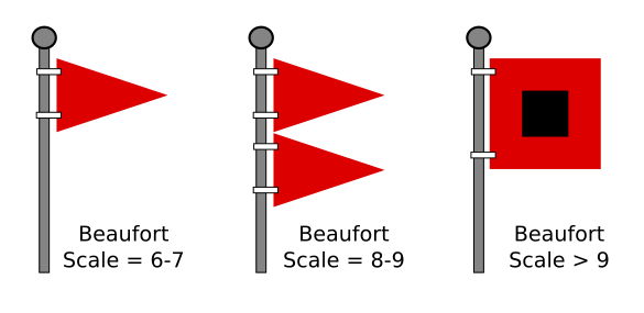
Warning flags associated with the Beaufort wind force scale. One pennant signifies wind speeds of 22-33 knots (25-38 miles per hour), two pennants signify wind speeds of 34-47 knots (39-54 miles per hour), and a square flag signifies wind speeds of 48 and higher knots (55 and higher miles per hour).
My baby boomer generation is known to be strange for many traits, a precursor of which might be the fact that I learned these in elementary school. (Created using Inkscape.)
This wind force scale was devised in 1805 by
Royal Navy officer,
Francis Beaufort(1774-1857), as a means to
quantify wind speed
data in
ships' logs. Its first use was during the
1831-1836 voyage of the HMS Beagle with
Charles Darwin on board. Wind force was initially observed by its affect on a ship's
sails; but, with the advent of
steam power, the wind force was estimated by the height of
sea waves. Presently, there are
electronic instruments that give a more precise
measure.
Wind was important to the
ancient Greeks, who were a
seafaring people. As I wrote in a
previous article (Educated Guessing, December 7, 2020), Book II of
Homer's Iliad lists 1186 Greek ships that transported
troops to fight in the
Trojan War. The Greeks
personified the four winds, called the
Anemoi, as
gods, with
Boreas as the north wind,
Zephyrus as the west wind,
Notus as the south wind, and
Eurus as the east wind.
The winds were
mysterious enough to the ancients that they were considered to be gods. Science has replaced this
romantic notion by explaining wind as a consequence of a
temperature gradient between
regions heated by the Sun. Since air above
land heats and cools faster than the
air above
water, warm air above land
expands and rises by
insolation during the
day. This causes heavier, cooler air to rush in to take its place, thereby creating wind. At
night, this process is reversed. Strong winds are the principal reason why siting
wind turbines offshore is a sensible approach.
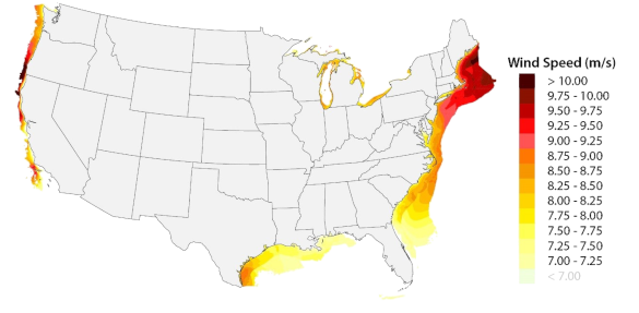
Wind speed map for United States offshore wind energy. (Figure 17 of Ref. 3.[3] Click for larger image.)
One
obstacle to offshore wind power has been
community resistance to having wind turbines spoil the
ocean view from their
beachfront homes. However, people are now seeing that transitioning away from
fossil fuel energy is essential to preventing their beachfront homes from being
washed into the sea. There were also concerns that offshore wind turbine operations would adversely impact the
marine ecosystem and
fishing. As the following map shows, the United States has considerable wind energy throughout the
contiguous 48 states, albeit less than the wind energy offshore. Siting wind turbines on land allowed an early access to wind energy, since erecting a wind turbine on land is easier than at sea, and there is an easy connection to the terrestrial
power grid.
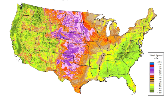
United States average annual wind speed at 80 meters. An average wind speed greater than 6.5 meters per second is suitable for wind power development. Wind turbines higher than 80 meter have access to greater wind speeds. (United States Department of Energy map, also available as a PDF file here. Click for larger image.)
As I first read on
Slashdot, one of my favorite
computer technology websites, a portion of the first large scale United States offshore wind project,
Vineyard Wind 1, achieved
first power on January 2, 2024.[4] On that date, one turbine provided about five
megawatts of
electricity to the power grid. Vineyard Wind 1 was the first United States offshore wind project to get full
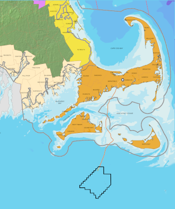
federal approval.[5] Vineyard Wind 1 is placed in federal wind energy area OCS-A-0501, which is 15 miles south of
Martha's Vineyard and
Nantucket (see map).[6] When completed, Vineyard Wind 1 will have 62 turbines with 321-foot-long
blades spaced about a
mile apart providing up to 800 megawatts of power through
subsea electrical cables to
mainland Massachusetts, 35 miles distant.[5] That's enough power for 400,000 homes.[5]
South Fork Wind, a much smaller offshore wind project off Long Island, New York, began producing electricity in early December, 2023.[5,7] When completed, this 132 megawatt wind farm will supply electricity to 70,000 homes in East Hampton, New York, the easternmost town in the state of New York. Its twelve turbines will not be visible at the East Hampton beaches.[7]
Location of Vineyard Wind 1.
(Created using Inkscape from this base map, and data from Vineyard Website.[6] Click for larger image.)
References:
- Sheldon Cooper Presents: Fun with Flags, Fandom.com.
- Homer, The Iliad, Alexander Pope, Trans., at Wikisource.
- Walt Musial, Donna Heimiller, Philipp Beiter, George Scott, and Caroline Draxl, "2016 Offshore Wind Energy Resource Assessment for the United States, Report no. NREL/TP-5000-66599, National Renewable Energy Laboratory, Golden, Colorado, September 1, 2016, doi:10.2172/1324533.
- America's First Large-Scale Offshore Wind Project Finally Begins Generating Electricity, Slahdot, January 6, 2024.
- Miriam Wasser, "Vineyard Wind, country's first large-scale offshore wind project, is producing clean electricity," WBUR, January 3, 2024.
- Vineyard Wind 1 Website.
- South Fork Wind Website.
Linked Keywords: Popularity; popular; science; technology; theme (narrative); themed; television sitcom; The Big Bang Theory; season; episode; peculiar; peculiarities; scientists; engineers; exaggeration; exaggerate; comedy; comedic effect; physicist; Sheldon Cooper; Internet video; online video; Bavaria; girlfriend; costume; pretzel; flag; Beaufort wind force scale; warning system; pennon; pennant; wind speed; knot (unit); miles per hour; square (geometry); baby boomer generation; strange; trait theory; trait; precursor; elementary school; Inkscape; Royal Navy; officer (armed forces); Francis Beaufort(1774-1857); quantification; quantify; data; maritime logbook; ships' log; 1831-1836 voyage of the HMS Beagle; Charles Darwin; sail; steam power; sea wave; electronic; instrumentation; instrument; measurement; measure; calm; breeze; gale; storm; tropical cyclone; hurricane; Ancient Greece; ancient Greeks; maritime; seafaring<; Homer; Iliad; troops; Trojan War; Greek mythology; personified; Anemoi; deity; god; Boreas (god); Zephyrus; Notus; Eurus; mystery; mysterious; romantic; temperature gradient; geography; region; insolation; heated by the Sun; regolith; land; atmosphere of Earth; air; water; thermal expansion; expand; daylight; night; wind turbine; offshore wind power; Wind speed map for the U.S. offshore wind energy technical resource area; map; United States; offshore wind power; offshore wind energy; obstacle; community; ocean; beach; beachfront; home; fossil fuel; coastal erosion; washed into the sea; marine ecosystem; fishing industry; contiguous United States; contiguous 48 states; electrical grid; power grid; average; annual; meter; meters per second; United States Department of Energy map; Slashdot; computing; computer technology; website; Vineyard Wind 1; megawatt; electricity; federal government of the United States; Martha's Vineyard; Nantucket; turbine blade; mile; submarine power cable; subsea electrical cable; mainland; Massachusetts; South Fork Wind; Long Island, New York; wind farm; East Hampton, New York; Inkscape.