Ultima Thule
January 7, 2019 Man is always pushing back his territorial frontiers, so the location of the most distant place has changed throughout history. The Roman Empire had extended to Britain by the 1st century, after Julius Caesar invaded during the Gallic Wars, but Rome's reach did not extend farther north. The farthest region on Earth in those days was known as Ultima Thule, from the Greek word, θουλη (Thoule), for the most northerly place.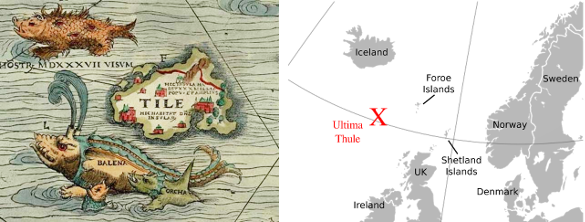
Ultima Thule (left) depicted as an island on the 1539 Carta Marina of Olaus Magnus (1490–1557). Also shown is its approximate location on a modern map. Alternatively, Ultima Thule has been placed as Norway, Iceland, Greenland, or the Shetland Islands. (Left image, and right image, a modified version of a map created by Ssolbergj, both from Wikimedia Commons.)
Ultima Thule has a long and interesting history. Greek historian, Polybius, wrote in his circa 140 BC Histories that Pytheas of Massalia claimed that Thule was in a region of amorphous material combining earth, air, and water.[1] Several centuries later, Strabo (c. 63 BC - c. AD 24) wrote in his Geographica that Thule was six days' sailing voyage north of Britain, and it was near the frozen sea. Avienus (c. 350 AD) wrote in his Ora Maritima that summer nights on Thule lasted only two hours, a clear reference to the diurnal cycle at high latitudes. Pliny the Elder in his 77 AD Natural History cited the claim by Pytheas that the Sun did not set at Thule in summer and did not rise in winter. Strabo, also citing Pytheas, wrote further that Thule was inhabited, and its people subsisted on millet, herbs, roots, fruits, and crudely processed grain. In later times, Ultima Thule was alternatively conceived to be Norway, Iceland, Greenland, or the Shetland Islands.

Land of the Midnight Sun - Excerpt from Pliny's Naturalis_Historia (Natural History) , Book 2, Chapter 78, describing the period of daylight on Thule (Thyle). "...during the solstitial period, as the sun approaches to the pole of the world, and his orbit is contracted, the parts of the earth that lie below him have a day of six months long, and a night of equal length when he is removed to the south pole. Pytheas of Marseilles informs us, that this is the case in the island of Thule..." (Original Latin and English translation via Tuft's University Project Perseus.[2-3])
Mankind has just extended its reach to a new, distant point, a minor planet with the not too memorable designation, (486958) 2014 MU69. The name of this trans-Neptunian object in the Kuiper belt incorporates the year of its discovery, 2014, by the Hubble Space Telescope. It now carries the Ultima Thule name. This minor planet has an apparent magnitude of about 27, so it's too faint to be observed by a terrestrial telescope and could only be imaged by Hubble. Ultima Thule was discovered in a deliberate search for a suitable trans-Neptunian object to be visited by the New Horizons spacecraft after its successful encounter with Pluto and its satellites on on July 14, 2015.
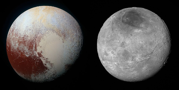
Pluto and one of its satellites, Charon, as imaged by the New Horizons spacecraft on July 14, 2015. Left image, an enhanced color view of Pluto combining blue, red and infrared images. Right image, Pluto's largest moon Charon. Both images from NASA/Johns Hopkins University Applied Physics Laboratory/Southwest Research Institute, via Wikimedia Commons.
New Horizons encountered Ultima Thule in the early hours of January 1, 2019, with closest approach at 05:33 UTC. At this encounter, New Horizons was 43.4 astronomical units (AU) from the Sun, so radio telemetry had a transit time of about six hours. While an early image was acquired (see below), the full data download will take 20 months, since the data rate is 1-2 kilobits per second. It's amazing that signals can be received on Earth from New Horizon's 12 watt X-band transmitter.
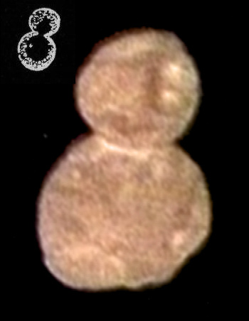
First color image of Ultima Thule, (486958) 2014 MU69.
The colors on this image were produced by combining near infrared, red and blue images taken at a distance of 85,000 miles on January 1, 2019.
While many have characterized the shape as a snowman, it reminded me of budding yeast, as shown in the inset image at the upper left hand corner.
(Ultima Thule image from NASA/Johns Hopkins University Applied Physics Laboratory/ Southwest Research Institute, and budding yeast image from The New Student's Reference Work, 1914 edition, vol. 5, p. 137, both via Wikimedia Commons)
References:
- Polybius, "The Histories," Book XXXIV, from vol. VI of the Loeb Classical Library edition, 1922 thru 1927, from Bill Thayer's Web Site at the University of Chicago.
- Pliny the Elder, "Naturalis Historia (in Latin)", Karl Friedrich Theodor Mayhoff, Ed. (Teubner, 1906), via Tuft's University Project Perseus.
- John Bostock and H.T. Riley, "The Natural History. Pliny the Elder," Taylor and Francis (London, 1855), Book 2, chapter 77, "Where the Days are the Longest and Where the Shortest," via Tuft's University Project Perseus.
- NASA New Horizons Website.