Climate Clues from Caves
June 8, 2015 The common perception of early man is as a caveman. However, as I wrote in a previous article (Lunar Caves, August 4, 2014), it doesn't appear that there would have been enough caves to house everyone. While there's fossil evidence that Neanderthals and Cro-Magnons took occasional refuge in caves, our ancestors more likely took shelter from most wild animals by staying in trees. Caves protect human artifacts from environmental degradation, so the presence of humans is more likely to be found in caves. Early art has been preserved along with the fossils, as exemplified by the photograph, below. As experience has shown with the Lascaux Caves, we need to be careful that such art, surviving after thousands of years, isn't destroyed in our lifetime.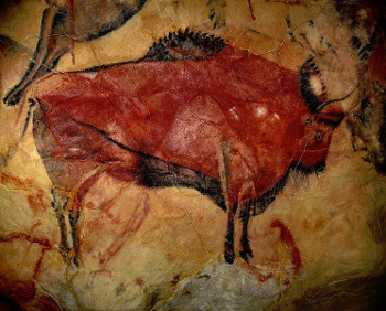 | Painting of a bison in the caves of Altamira, near Santander, Spain. (Photo by Baperukamo, via Wikimedia Commons.) |
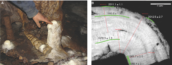 |
| Analysis of a Mawmluh cave stalagmite. Left, the stalagmite in its natural state. Right, cross section annotated with discovered dates and their uncertainty.(Vanderbilt University images by Jessica Oster.)[2] |
"Now that we have shown that the Mawmluh cave record agrees with the instrumental record for the last 50 years, we hope to use it to investigate relationships between the Indian monsoon and El Niño during prehistoric times such as the Holocene."[2]The technique might be a way to probe the details of the Holocene Climate Optimum, a period of global warming occurring from nine to six thousand years ago. This was not a mild warming, since the average global temperature was 4-6 °C higher than today. This is about the same degree of warming expected from our present build up of atmospheric greenhouse gases, and information about the monsoon during the Holocene would be important information. The monsoon provides the Indian subcontinent with 75% of its annual rainfall.[2] Such research in using mineral deposits in caves as an indirect technique to examine climate started in the 1990s. However, each cave is unique, and things such as its water transport pathways must be studied for years before it's useful as a climate gauge.[2] This research was supported by the National Science Foundation, the Cave Research Foundation, the Geological Society of America and the Swiss National Science Foundation.[2]
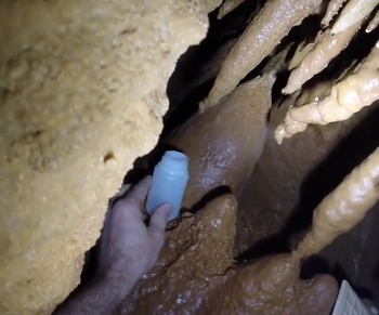 | Collection of stalactite liquid runoff. The particular mechanisms of water flow into a cave must be quantified to make it a useful climate proxy. (Still image from a Vanderbilt University YouTube Video.)[3] |
References:
- Christopher G. Myers, Jessica L. Oster, Warren D. Sharp, Ralf Bennartz, Neil P. Kelley, Aaron K. Covey, and Sebastian F.M. Breitenbach, "Northeast Indian stalagmite records Pacific decadal climate change: Implications for moisture transport and drought in India," Geophysical Research Letters (In Press, May 19, 2015), DOI: 10.1002/2015GL063826.
- David Salisbury, "Deciphering clues to prehistoric climate changes locked in cave deposits," Vanderbilt University Press Release, May 22, 2015.
- Deciphering clues to prehistoric climate changes locked in cave deposits, Vanderbilt University YouTube Video, May 22, 2015.